
Hello, first of all, I recall that regattagame works in association French law 1901, and thus lives only with your donations, no staff member is paid. No profit.
The "Pacha" mode: You can make a donation to the regattagame association, allowing to cover the costs of running, server and his hosting and when possible, some gifts on some races.
For a donation of 20 euros per year, or more if you want, you will receive in return 9 programs, 9 waypoints, the possibility to customize the interface, and especially the dual programming, very very useful!!
A group of the most experienced players has formed to welcome and help the newcomers and those who need it, don’t hesitate!
viewtopic.php?f=123&t=548
Table of contents
1 – The Interface
2 – The compass
3 – The map
4 – The winds
5 – The polars
6 – Update of poistion
7 – The regulator
8 – The projection
9 – Programming
10 –The « tools » tab
11 – The « planning » tab, the programmer
12 – The cells
13 - Boats search, and sending messages
14 – The waypoints
1 – The Interface
The login screen http://www.regattagame.net/

With this screen you can :
- Register, log in, test the game with the demo boat (without registration) "full options"
- See the challenges, current or future races with their coefficient/points.
- Send us an email (envelope at the top) if you have problems with registration or login, or forgotten codes.
- Choose your language.
We are now connected
Here you have access to races and challenges, various information, ranlings and forum, etc...
You can also change your language.
Choose a race.

Here you can access to a race (e.g.: Tonio’s cup), make a donation, abandon the race.
WARNING: Abandonment is definitive, beware of a false manoeuvre, it has happened often.
You also have pictures of departures and arrivals, routes, and more race instructions if there are any.
Come on, let’s go on the race

The navigation buttons will be detailed later.
IMPORTANT TO KNOW:
1) the "refresh" button (white arrow turns on green background) is also used to adapt the size of the map to the size of your browser window. So click it systematically at the opening of each race.
2) The full screen mode is accessible via the F11 key of your keyboard + "refresh" button to adapt the size.
3) To access the forum, the challenges, if you are on a race, or the races if you are on a challenge, you must leave the race with the big cross all right at the top.
Your boat is surrounded by a red circle, the pachas can change the color in their profile.
From left to right in the info bar at the top:
- The race on which you are.
- The name of your boat.
- The date and time of the last update of your position.
- The minute of the position update (different on each race)
- Your ranking on the race
- The classification of the race.
- Inter-boat messaging (green if message)
- Add friends (will be yellow on the interface if you tick the "friends" button in the navigation tools.
- Link to this manual (lifebuoy)
- The "refresh" button.
- Server load: green=ok, yellow= works, red=works a lot.
- The number of connected boats.
- Leave the race.
IMPORTANT: We advise you to empty the cache of your browser regularly
Let's see this in details:
2 – The compass
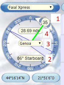
Some information about your boat :
1 ) The heading: You can change it either by catching the ball with the mouse, or degree by degree with the arrows on each side of the ball.
2) Wind angle (TWA)
3) The sail is selected from the drop-down strip by clicking on it. How to choose it will be explained later.
4) The sail is selected from the drop-down strip by clicking on it. How to choose it will be explained later.
At the bottom, the position of the boat, here in degrees/minutes/seconds, choice by default. In your profile you can choose in decimal degrees
3 – The Map
The coastlines are not precise at low zoom level. The more you zoom, the more the coastlines become precise.
When sailing close to the coasts, it's better to zoom in a bit to get the little details. Some very little details only appears at full zoom level.
There are 5 levels of maps, depending of the zoom level.
4 – The winds
Top: Strength and Direction
NOTICE: In order to minimize the advantage of those who could get the NOAA winds prediction earlier than others, a random factor is applied to the winds prediction: -10 to +10 % on the wind strength and from -10° to +10° on the angle. It’s the engine that decides, we have no action possible (only on the winds at +12h).
To display the strength and angle of cell's wind: move the mouse over the wind arrow.
After some problems of recovery of all the winds at NOAA, on some races we will have less forecast than the 156h indicated, this is visible to the right of the logo.
New forecasts are available a few minutes after 06h30 and 18h30.
Dont’t worry if there is a little delay
The wind range changes at 7h5X (iteration minute) and 19h5X, but the new winds at 0h are not visible on the interface only after 8h00 and 20h00.
The logo on the left shows you where the download is, which starts at 5h30 and 17h30
 Orange: the download of the wind forecasts is on-going
 Yellow: the winds are loaded but not yet visible, they will be at 6h30 and 18h:30.
 Green : the new forecasts are visible.
If the logo stays orange after 6h30 and 18h30, it means that all the winds are not yet charged,in which case it will go directly green when it is good.
 Red:
Red:- lasting only 1 minute after 07h30 / 19h30: incomplete download on time, setting the forecasts shift (blue);
- continuous red lasting more than 1 minute after 07h30 / 19h30: download failure, please drop a message on the chat or on the forum.
 Blue:
Blue: In case of persistent problem with the NOAA which provides us with the winds, the logo changes to blue.
At approximately 7h30 or 19h30, this means that we will use the winds from the previous forecast without any change.
 Purple: download failure: invalid winds zone extent, please drop a message on the chat or on the forum.
Season 2 soon on your topic